In the fall of 2003 I saw this painting by Nan Ferrier (of Tyne Valley, PEI) and had to have it. It's titled, Alma Corner. When I go home to Alma I drive up to this corner on the Western Road and turn left/west onto the Centerline Road and in the road to Mom and Dads where they still live. Today, 2012, the only building that remain at the corner in this painting is the little Anglican Church up the road a short distance.

I grew up on our family's homestead farm on the Centerline Road in Alma and just up the road about a mile was my father's childhood home in Lauretta.
In the early days of settlement throughout the Island the school system determined that no school would be any further than 3 miles apart so the children wouldn't have to walk any further than 1-1/2 miles to school. - this created alot of schools and around each school a community grew - that's why Prince Edward Island has so many communities that seem to be a short distance from the next community.
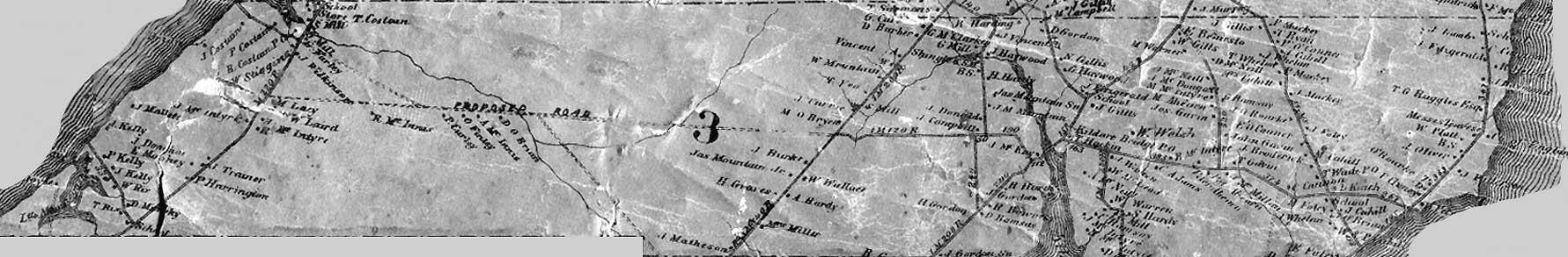
Alma is located on two major road - the Western Road and the Centerline Road. Alma borders on the communities of Woodvale and Elmsdale (north/south) and by Montrose and Lauretta (east/west) and located about 4 miles from Alberton. The community covers an approximately 5 miles in diameter. At one time Alma had the following public buildings: a whistle-stop train station; a school; a Baptist church; an Anglican Church; three corner stores; a post office; a cheese factory; and dance halls. Today only one of these survive - the Anglican Church. Settlement in Alma began around the 1850's.Lauretta is located mainly on the Centerline Road with two smaller roads going off into the woods. From one side of the community to the other is no more than two miles. Lauretta is bordered by the communities Alma and St. Lawrence (east/west) and by St. Edwards and Elmsdale (north/south). Lauretta was a very small community - it had a school and a post office (likely in a resident home). By the early 1970's every house and building in the community had completely disappeared - not one was left. Many of the farms were bought by the government and used as community pastures. Settlement in Lauretta began sometime in the 1860's.
I hope you enjoy this blog - any information you have to offer or correct is welcome.
That is an awesome pic you bought Carter . At first I could not figure the pic out , but after looking at it for a few minutes I then remembered all the buildings in it and where they were located at one time . I do remember painting the house at the bottom because I was working with Fred Horne back then and the owner gave us a tip for such a good job we did which Fred passed on to us .
ReplyDelete