I had the pages copied where the surveyors talks about being in the Alma area.

-------------------------------------------------------------------------------------
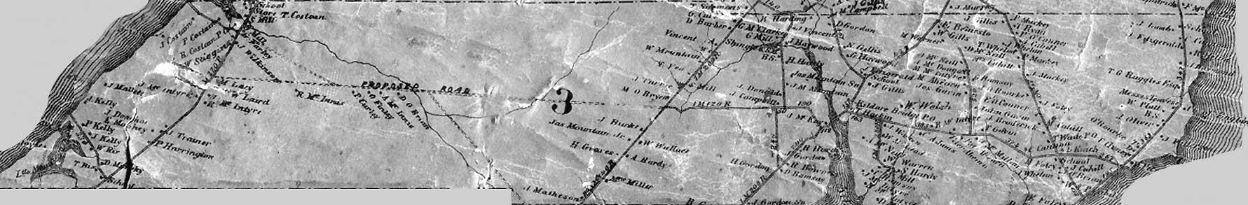
Pg. 184
Mr. James B. Leard, on
Employed to lay off 170 Acres sold to Thomas Platt. Description from the Deed "Corner of a stake fixed in the North West corner of land owned by Thomas Mountain and from thence running S. 80 chs, thence East 21.26. thence North 80 chs to Mountains line thence West along said L. 21.26 to place of count 170 Ac. to James B. Leard to Thomas Platts
To find the course of the side lines West to the Line between James Gordon & John Gordon & found it N 6°15' E right from Page 422 Book 6. I find the course is N 6°20'E maybe(?)
John Muttart is to have 154 Acres off the East side and it is to be laid off first. The farm S. of the Rd. is 1.65 wider than it is N of the Rd & this jog is on the E side from the Centre of the Road at the E. Line set square across to W. & chd to South.
At 11.38 the S.B.
‑ 12.31 the new D.L. between Lots 3 & 4 Then there is half the width of the old 100 be on the W side from S.B. extending S. into
Then from the cross Line on the W side of the Old farm Ch.d to N.
At 2.05 Centre of the Road
At 29.00 had lost a pin gave up for the night.
Pg. 186
James B. Leard continued
Went to the Centre Line Rd. & from the N.E.L. of John L. Muttart's old 100 Ac. Ch.d West along said Road 9.48. to a Post set in the N.W.L., Muttart's as it ought to be 8.34.
From
Set at the Stake at the
At 22.00 a square post 0.23 to E of our Line, this no doubt is Mountain's S.E.L. & on the Old D.L. between Plots 16 & 17.
AT 60.00 the stump where we lost the pin last night.
This makes 101.31 from D.L. to the
There is a strip running W from the old 100 Ac. & North of the D.L. E and 5.17 which makes the length of the Block to West 73.21 and requires 7.63 on our cross line to make the 154 Acres & then to run N6°20' E must, measured this distance & set a line as above.
Then went West to the Post in the N.E.L. of Stephen Week's farm & set at right angle to the above course E'd & Ch.d
At 21.26 set a mark of Platt's width
At 28.00 left off for the night.
Wendesday, Oct 18
Continued the L on the W of John Muttarts? to N until intersected by the L. ran last night then went to the 28.00 & continue to E to said L 29.0 say 29.00 Then went back to the 21.26 Platts width & set a boundary between sd. Platts & Theodore Gordon N6°20' E Then went W to Gordon's W B. &
Pg. 255 & 256
Honourable John Yeo for Joseph Green, Lot 3 Employed to run the Line on the W side of his land fronting on & North of the
Went to the S.E.L. of 60 Acres bought by Rich'd Costain from the late George Kelly this being the D.L. between Plots No. 9 & 10, of Lot 3, set here and ran S.V or to the Centre Line Road. Came out near the centre of the Costain
Var 8° 20"
1 day $ 3.00
to be Chd to Mr. Yeo.
Pg. 217
John Donalds Lot 3
Employed to lay off 80 acres sold to Archibald McMurdock on the E. side of 160 Acres on the S side of the
Pg. 218
Andrew Peters Lot 3,Employed to set a L.S. on the W side of 50 acres purchased from Allan McPherson. Went to the corner of the fence at Wm. Raynor's N W L & Ch.d on the Rd. 5.00 set
Var 8°20' $ 1.50
If paid next week to be a Dollar.
Pg. 385
L
Rich.d Costain & Charles Veno
Employed to run the Line between said parties Mr. Anderson having run it part way before.
Went to the centre of the
At 35.05 the River this for far N. V & had run the line 1.82 = 36.87 across the River set here and run N Var & Ch.d
‑ 101.20 the line of
Var 8°35
John Clay
Landsurveyor
Veno's half 2.00By Cash .45
Due $ 1.55
is to send it by mail from R. Costain's
paid in full
No comments:
Post a Comment